
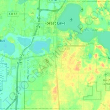
Forest Lake topographic map
Interactive map
Click on the map to display elevation.
About this map
Name: Forest Lake topographic map, elevation, terrain.
Average elevation: 279 m
Minimum elevation: 267 m
Maximum elevation: 298 m
Other topographic maps
Click on a map to view its topography, its elevation and its terrain.
Woodbury
United States > Minnesota > Washington County
Woodbury, Washington County, Minnesota, United States
Average elevation: 297 m
Twin Pine Mobile Home Park
United States > Minnesota > Washington County > Hugo
Twin Pine Mobile Home Park, Hugo, Washington County, Minnesota, 55038, United States
Average elevation: 282 m
Afton
United States > Minnesota > Washington County
Afton, Washington County, Minnesota, 55001, United States
Average elevation: 259 m
Oakdale
United States > Minnesota > Washington County > Oakdale
Oakdale, Washington County, Minnesota, 55128, United States
Average elevation: 302 m
Grey Cloud Island
United States > Minnesota > Washington County > Grey Cloud Island
Grey Cloud Island, Washington County, Minnesota, United States
Average elevation: 221 m
Cottage Grove
United States > Minnesota > Washington County > Cottage Grove
Cottage Grove, Washington County, Minnesota, United States
Average elevation: 250 m