
Nuuk topographic map
Interactive map
Click on the map to display elevation.
About this map
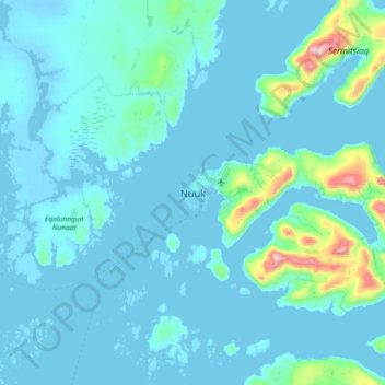
Name: Nuuk topographic map, elevation, terrain.
Location: Nuuk, Sermersooq, 3900, Greenland (64.01668 -51.89594 64.33668 -51.57594)
Average elevation: 76 m
Minimum elevation: -6 m
Maximum elevation: 1,170 m
Nuuk's sports clubs include Nuuk IL (established in 1934), B-67, and GSS Nuuk. Nuuk Stadium is a multi-purpose stadium, used mostly for football games. The stadium has a capacity of 2,000. The stadium can also be used as an entertainment venue: the Scottish rock band Nazareth performed at the venue. Nuuk also has the Godthåbhallen, a handball stadium. It is the home of the Greenland men's national handball team and has a capacity of 1,000. There is a hill for alpine skiing with an altitude difference around 300 meters on the mountain Lille Malene, with the valley station close to the airport terminal. There is also the Nuuk golf course, the only arctic golf course in the world.
Other topographic maps
Click on a map to view its topography, its elevation and its terrain.
Jakobshavn Glacier
Jakobshavn Glacier, Avannaata, Greenland
Average elevation: 452 m
Ittoqqortoormiit
Ittoqqortoormiit, Sermersooq, 3980, Greenland
Average elevation: 80 m
Kangerlussuaq
Kangerlussuaq, Sisimiut, Qeqqata, Greenland
Average elevation: 114 m
Traill-iup Immikkeertivi
Traill-iup Immikkeertivi, Sermersooq, Greenland
Average elevation: 0 m
Geographical Society Island
Geographical Society Island, Sermersooq, Greenland
Average elevation: 178 m