
Ashby Woulds topographic map
Interactive map
Click on the map to display elevation.
About this map
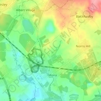
Name: Ashby Woulds topographic map, elevation, terrain.
Average elevation: 111 m
Minimum elevation: 75 m
Maximum elevation: 169 m
Other topographic maps
Click on a map to view its topography, its elevation and its terrain.
Castle Donington
United Kingdom > England > North West Leicestershire > Castle Donington
Castle Donington, Leicestershire, East Midlands, England, DE74 2NS, United Kingdom
Average elevation: 62 m
Ashby de la Zouch
United Kingdom > England > North West Leicestershire > Ashby de la Zouch
Ashby de la Zouch, Leicestershire, East Midlands, England, LE65 1AN, United Kingdom
Average elevation: 128 m
Measham
United Kingdom > England > North West Leicestershire > Measham
Measham, North West Leicestershire, Leicestershire, East Midlands, England, DE12 7EB, United Kingdom
Average elevation: 97 m
Normanton le Heath
United Kingdom > England > North West Leicestershire > Normanton le Heath
Normanton le Heath, North West Leicestershire, Leicestershire, East Midlands, England, LE67 2TB, United Kingdom
Average elevation: 123 m
Oakthorpe
United Kingdom > England > North West Leicestershire > Oakthorpe
Oakthorpe, North West Leicestershire, Leicestershire, East Midlands, England, DE12 7RB, United Kingdom
Average elevation: 94 m
Osgathorpe
United Kingdom > England > North West Leicestershire > Osgathorpe
Osgathorpe, North West Leicestershire, Leicestershire, East Midlands, England, LE12 9SZ, United Kingdom
Average elevation: 97 m