
Hoton topographic map
Interactive map
Click on the map to display elevation.
About this map
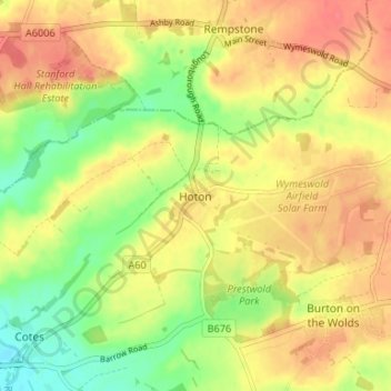
Name: Hoton topographic map, elevation, terrain.
Average elevation: 69 m
Minimum elevation: 37 m
Maximum elevation: 93 m
Other topographic maps
Click on a map to view its topography, its elevation and its terrain.
Baxter Store
United Kingdom > England > Charnwood > Loughborough
Baxter Store, Loughborough, Charnwood, Leicestershire, East Midlands, England, LE11 1TG, United Kingdom
Average elevation: 45 m
Shepshed
United Kingdom > England > Charnwood > Shepshed
Shepshed, Leicestershire, East Midlands, England, LE12 9AN, United Kingdom
Average elevation: 79 m
Thrussington
United Kingdom > England > Charnwood > Thrussington
Thrussington, Charnwood, Leicestershire, East Midlands, England, LE7 4TS, United Kingdom
Average elevation: 75 m
Barkby
United Kingdom > England > Charnwood > Barkby
Barkby, Charnwood, Leicestershire, East Midlands, England, LE7 3QG, United Kingdom
Average elevation: 72 m
Charnwood
United Kingdom > England > Charnwood
Charnwood, Leicestershire, East Midlands, England, United Kingdom
Average elevation: 47 m
Thurcaston and Cropston
United Kingdom > England > Charnwood
Thurcaston and Cropston, Charnwood, Leicestershire, East Midlands, England, United Kingdom
Average elevation: 74 m
Ratcliffe on the Wreake
United Kingdom > England > Charnwood
Ratcliffe on the Wreake, Charnwood, Leicestershire, East Midlands, England, United Kingdom
Average elevation: 69 m
Quorndon
United Kingdom > England > Charnwood
Quorndon, Charnwood, Leicestershire, East Midlands, England, United Kingdom
Average elevation: 57 m
Kingston Brook
United Kingdom > England > Charnwood
Kingston Brook, Charnwood, Leicestershire, East Midlands, England, LE12 6TD, United Kingdom
Average elevation: 94 m
East Goscote
United Kingdom > England > Charnwood
East Goscote, Charnwood, Leicestershire, East Midlands, England, United Kingdom
Average elevation: 61 m