
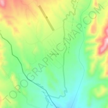
Razmak topographic map
Interactive map
Click on the map to display elevation.
About this map
Name: Razmak topographic map, elevation, terrain.
Average elevation: 2,011 m
Minimum elevation: 1,868 m
Maximum elevation: 2,233 m
Other topographic maps
Click on a map to view its topography, its elevation and its terrain.
Shewa
Pakistan > Khyber Pakhtunkhwa > North Waziristan District
Shewa, Shewa Tehsil, North Waziristan District, Bannu Division, Khyber Pakhtunkhwa, Pakistan
Average elevation: 673 m
Land
Pakistan > Khyber Pakhtunkhwa > North Waziristan District
Land, Datta Khel Tehsil, North Waziristan District, Bannu Division, Khyber Pakhtunkhwa, Pakistan
Average elevation: 1,113 m