
Kirehe topographic map
Interactive map
Click on the map to display elevation.
About this map
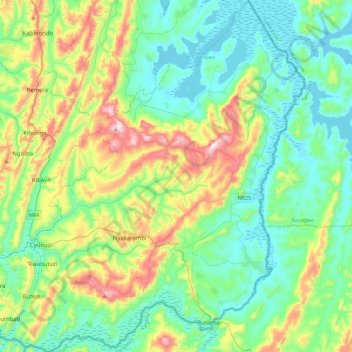
Name: Kirehe topographic map, elevation, terrain.
Location: Kirehe, East Province, Rwanda (-2.41941 30.45849 -1.97123 30.89907)
Average elevation: 1,447 m
Minimum elevation: 1,282 m
Maximum elevation: 1,911 m
Other topographic maps
Click on a map to view its topography, its elevation and its terrain.
Karangazi
Rwanda > East Province > Karangazi
Karangazi, Nyagatare District, East Province, Rwanda
Average elevation: 1,393 m
Kibaya
Rwanda > East Province > Murama > Kibaya
Kibaya, Murama, Ngoma District, East Province, Rwanda
Average elevation: 1,506 m
Bushenyi
Rwanda > East Province > Bushenyi
Bushenyi, Rwamagana District, East Province, Rwanda
Average elevation: 1,526 m
Kirehe
Rwanda > East Province > Kirehe
Kirehe, Kirehe District, East Province, Rwanda
Average elevation: 1,491 m
Karama
Rwanda > East Province > Karama
Karama, Nyagatare, East Province, Rwanda
Average elevation: 1,573 m