
Komańcza topographic map
Interactive map
Click on the map to display elevation.
About this map
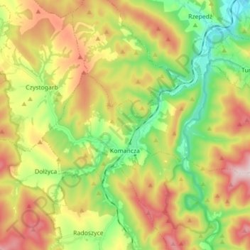
Name: Komańcza topographic map, elevation, terrain.
Average elevation: 564 m
Minimum elevation: 398 m
Maximum elevation: 779 m
Other topographic maps
Click on a map to view its topography, its elevation and its terrain.
Lalin
Poland > Subcarpathian Voivodeship > Sanok County
Lalin, gmina Sanok, Sanok County, Subcarpathian Voivodeship, Poland
Average elevation: 350 m
Sanok
Poland > Subcarpathian Voivodeship > Sanok County > Sanok
Sanok, Sanok County, Subcarpathian Voivodeship, Poland
Average elevation: 354 m
Falejówka
Poland > Subcarpathian Voivodeship > Sanok County
Falejówka, gmina Sanok, Sanok County, Subcarpathian Voivodeship, Poland
Average elevation: 379 m