
Nieder-Olm topographic map
Interactive map
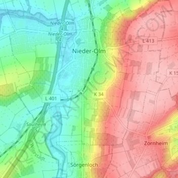
Click on the map to display elevation.
About this map
Name: Nieder-Olm topographic map, elevation, terrain.
Average elevation: 174 m
Minimum elevation: 110 m
Maximum elevation: 249 m
The town's average elevation lies at some 150 m above sea level. The highest elevation within municipal limits is the Mühlberg at 243 m in the northeast between Nieder-Olm and Mainz-Ebersheim.
Other topographic maps
Click on a map to view its topography, its elevation and its terrain.
Nierstein
Germany > Rhineland-Palatinate > Landkreis Mainz-Bingen
Nierstein, Rhein-Selz, Landkreis Mainz-Bingen, Rhineland-Palatinate, 55283, Germany
Average elevation: 124 m
Bingen am Rhein
Germany > Rhineland-Palatinate > Landkreis Mainz-Bingen
Bingen am Rhein, Landkreis Mainz-Bingen, Rhineland-Palatinate, 55411, Germany
Average elevation: 172 m