
Moros topographic map
Interactive map
Click on the map to display elevation.
About this map
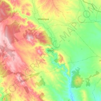
Name: Moros topographic map, elevation, terrain.
Location: Moros, Comunidad de Calatayud, Zaragoza, Aragon, Spain (41.36687 -1.91315 41.42871 -1.75219)
Average elevation: 777 m
Minimum elevation: 586 m
Maximum elevation: 1,013 m
Moros is one of the most attractive and picturesque villages of its kind in the area. Its narrow streets zigzag from the square at its highest elevation down to the river bed below. The houses are the main feature of the town. Hundreds of houses have been built tightly against the sunny side of the mountain. They are built with mud and decorated with red and ochre Arabic tiles. Each level of houses rises above the one beneath it to catch the sun as it rises over the valley.
Other topographic maps
Click on a map to view its topography, its elevation and its terrain.
Calatayud
Spain > Aragon > Comunidad de Calatayud
Calatayud, Comunidad de Calatayud, Zaragoza, Aragon, 50300, Spain
Average elevation: 693 m
Ariza
Spain > Aragon > Comunidad de Calatayud
Ariza, Comunidad de Calatayud, Zaragoza, Aragon, 50220, Spain
Average elevation: 801 m
Mara
Spain > Aragon > Comunidad de Calatayud
Mara, Comunidad de Calatayud, Zaragoza, Aragon, Spain
Average elevation: 773 m
Alhama de Aragón
Spain > Aragon > Comunidad de Calatayud > Alhama de Aragón
Alhama de Aragón, Comunidad de Calatayud, Zaragoza, Aragon, Spain
Average elevation: 763 m