
Mora de Rubielos topographic map
Interactive map
Click on the map to display elevation.
About this map
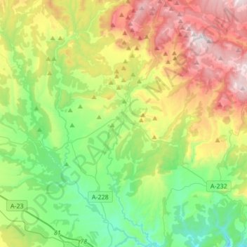
Name: Mora de Rubielos topographic map, elevation, terrain.
Location: Mora de Rubielos, Gúdar-Javalambre, Teruel, Aragon, Spain (40.14064 -0.81911 40.34682 -0.66061)
Average elevation: 1,134 m
Minimum elevation: 762 m
Maximum elevation: 1,798 m
The town lies at an altitude of 1035 m; it has a mid-mountain climate, dry with cold winters and mild summers. Its average annual temperature is 11.1 °C and its average rainfall is 550 mm.
Other topographic maps
Click on a map to view its topography, its elevation and its terrain.
Maya
Spain > Aragon > Gúdar-Javalambre > Mora de Rubielos
Maya, Mora de Rubielos, Gúdar-Javalambre, Teruel, Aragon, Spain
Average elevation: 1,120 m
Valdelinares
Spain > Aragon > Gúdar-Javalambre
Valdelinares, Gúdar-Javalambre, Teruel, Aragon, Spain
Average elevation: 1,723 m