
Sepik River topographic map
Interactive map
Click on the map to display elevation.
About this map
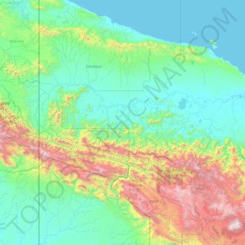
Name: Sepik River topographic map, elevation, terrain.
Location: Sepik River, Momase Region, Papua New Guinea (-5.24054 140.94098 -3.81427 144.54255)
Average elevation: 647 m
Minimum elevation: 0 m
Maximum elevation: 4,166 m
Other topographic maps
Click on a map to view its topography, its elevation and its terrain.
Goodenough Island
Like much of New Guinea, the climate is tropical with high temperatures and humidity throughout the year. The northwest monsoon season lasts from December to March and brings sudden rain squalls. From May to October southeasterly winds are cooler and more gentle. Tropical cyclones are infrequent. Rainfall…
Average elevation: 263 m