
Seven Springs topographic map
Interactive map
Click on the map to display elevation.
About this map
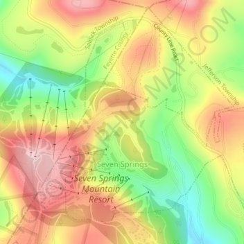
Name: Seven Springs topographic map, elevation, terrain.
Location: Seven Springs, Somerset County, Pennsylvania, United States (40.01658 -79.30551 40.03894 -79.27556)
Average elevation: 804 m
Minimum elevation: 678 m
Maximum elevation: 912 m
Seven Springs has the distinction of being, in elevation, the highest borough in Pennsylvania, at 2,530 feet (770 m). It sits along the crest of Laurel Hill, a major north–south ridge of the Allegheny Mountains.
Other topographic maps
Click on a map to view its topography, its elevation and its terrain.
2768 feet
United States > Pennsylvania > Somerset County > Jefferson Township
2768 feet, Jefferson Township, Somerset County, Pennsylvania, 15502, United States
Average elevation: 811 m
Somerset
United States > Pennsylvania > Somerset County > Somerset
Somerset, Somerset County, Pennsylvania, United States
Average elevation: 662 m
Windber
United States > Pennsylvania > Somerset County
Windber, Somerset County, Pennsylvania, 15963, United States
Average elevation: 560 m
Confluence
United States > Pennsylvania > Somerset County
Confluence, Somerset County, Pennsylvania, United States
Average elevation: 459 m