
Mahajanga topographic map
Interactive map
Click on the map to display elevation.
About this map
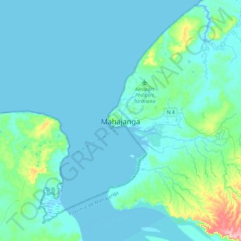
Name: Mahajanga topographic map, elevation, terrain.
Location: Mahajanga, Boeny, Province de Mahajanga, Madagascar (-15.87815 46.15726 -15.55815 46.47726)
Average elevation: 17 m
Minimum elevation: -1 m
Maximum elevation: 171 m
Other topographic maps
Click on a map to view its topography, its elevation and its terrain.