
Aysén topographic map
Interactive map
Click on the map to display elevation.
About this map
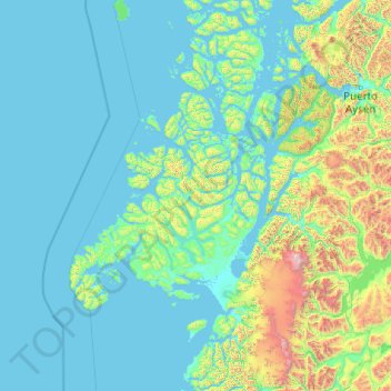
Name: Aysén topographic map, elevation, terrain.
Location: Aysén, Provincia de Aysén, Aysén Region, Chile (-47.34019 -75.64900 -44.95362 -71.96000)
Average elevation: 340 m
Minimum elevation: -3 m
Maximum elevation: 3,891 m
Other topographic maps
Click on a map to view its topography, its elevation and its terrain.
Morel
Chile > Aysén Region > Provincia de Aysén > Cisnes
Morel, Cisnes, Provincia de Aysén, Aysén Region, Chile
Average elevation: 9 m
Cerro Forelius
Chile > Aysén Region > Provincia de Aysén > Aysén
Cerro Forelius, Aysén, Provincia de Aysén, Aysén Region, Chile
Average elevation: 203 m
Monte San Valentin
Chile > Aysén Region > Provincia de Aysén > Aysén
Monte San Valentin, Aysén, Provincia de Aysén, Aysén Region, Chile
Average elevation: 3,370 m
Puerto Aysén
Chile > Aysén Region > Provincia de Aysén
Puerto Aysén, Aysén, Provincia de Aysén, Aysén Region, 6000186, Chile
Average elevation: 524 m