
Monduli topographic map
Interactive map
Click on the map to display elevation.
About this map
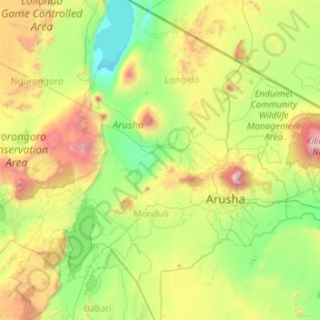
Name: Monduli topographic map, elevation, terrain.
Location: Monduli, Arusha, Northern Zone, Tanzania (-4.15051 35.82073 -2.75910 36.65031)
Average elevation: 1,369 m
Minimum elevation: 705 m
Maximum elevation: 4,430 m
Disease in this area is a problem. People suffer from various diseases, such as malaria. The majority of diseases are mosquito-borne and difficult to avoid. However, due to the higher altitude of the area, mosquitoes are not as common. Monduli has one hospital, one health centre, and 22 dispensaries.
Other topographic maps
Click on a map to view its topography, its elevation and its terrain.
Ngorongoro Crater
Ngorongoro Crater, Lemala Ascent & Descent Road, Ngorongoro, Arusha, Northern Zone, Tanzania
Average elevation: 1,963 m
Mto wa Mbu
Mto wa Mbu, Monduli, Arusha, Northern Zone, Tanzania
Average elevation: 1,019 m
Oldupai Gorge
Oldupai Gorge, Arusha, Northern Zone, Tanzania
Average elevation: 1,494 m
Lake Natron
Lake Natron, Natron_Serengetti, Sonjo, Ngorongoro, Arusha, Northern Zone, Tanzania
Average elevation: 861 m
Ngorongoro Conservation Area
Ngorongoro Conservation Area, Ngorongoro, Arusha, Northern Zone, Tanzania
Average elevation: 1,600 m
Lake Manyara National Park
Lake Manyara National Park, Karatu, Arusha, Northern Zone, 23601, Tanzania
Average elevation: 1,177 m
Ol Doinyo Lengai
Ol Doinyo Lengai, Ngorongoro, Arusha, Northern Zone, Tanzania
Average elevation: 2,356 m
Makao Mapya
Tanzania > Arusha > Makao Mapya
Makao Mapya, Arumeru, Arusha, Northern Zone, Tanzania
Average elevation: 911 m
Mount Meru
Mount Meru, Arumeru, Arusha, Northern Zone, Tanzania
Average elevation: 3,884 m