
San Cristobal topographic map
Interactive map
Click on the map to display elevation.
About this map
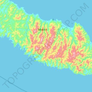
Name: San Cristobal topographic map, elevation, terrain.
Location: San Cristobal, Makira-Ulawa Province, Solomon Islands (-10.95415 161.52823 -10.31415 162.16823)
Average elevation: 142 m
Minimum elevation: -1 m
Maximum elevation: 1,028 m
Other topographic maps
Click on a map to view its topography, its elevation and its terrain.
Uki
Solomon Islands > Makira-Ulawa Province
Uki, Makira-Ulawa Province, Solomon Islands
Average elevation: 18 m