
Municipio Santos Marquina topographic map
Interactive map
Click on the map to display elevation.
About this map
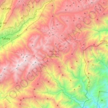
Name: Municipio Santos Marquina topographic map, elevation, terrain.
Location: Municipio Santos Marquina, Merida State, 5116, Venezuela (8.41116 -71.11589 8.73628 -70.83069)
Average elevation: 2,910 m
Minimum elevation: 629 m
Maximum elevation: 4,918 m
Other topographic maps
Click on a map to view its topography, its elevation and its terrain.
El Rincón
Venezuela > Merida State > Municipio Miranda
El Rincón, Parroquia La Venta, Municipio Miranda, Merida State, Venezuela
Average elevation: 3,355 m