Geolocate

Grass Island topographic map

Interactive map

Click on the map to display elevation.

About this map

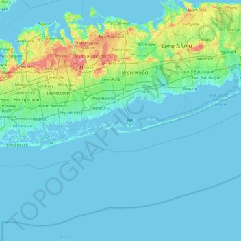
Name: Grass Island topographic map, elevation, terrain.

Location: Grass Island, Suffolk County, New York, 11702, USA (40.33232 -73.61567 40.97232 -72.97567)

Average elevation: 12 m

Minimum elevation: -2 m

Maximum elevation: 113 m

Other topographic maps

Click on a map to view its topography, its elevation and its terrain.

Prospect Park

USA > New York > New York City

Average elevation: 34 m

East River

USA > New York > New York City

Average elevation: 15 m

Midtown South

USA > New York > New York City

Average elevation: 20 m

Rochester

USA > New York > Rochester

Average elevation: 140 m

Manhattan

USA > New York > New York City

Average elevation: 12 m

Stewart State Forest

USA > New York > Rock Tavern

Average elevation: 132 m

Corfu

USA > New York > Corfu

Average elevation: 264 m

Lock E14

USA > New York > Palatine Bridge

Average elevation: 131 m

Beebe Lake

USA > New York

Average elevation: 255 m