
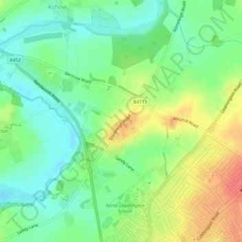
Blackdown topographic map
Interactive map
Click on the map to display elevation.
About this map
Name: Blackdown topographic map, elevation, terrain.
Average elevation: 69 m
Minimum elevation: 47 m
Maximum elevation: 99 m
Other topographic maps
Click on a map to view its topography, its elevation and its terrain.
Norton Lindsey
United Kingdom > England > Warwick > Norton Lindsey
Norton Lindsey, Warwick, Warwickshire, West Midlands, England, United Kingdom
Average elevation: 93 m
Beausale
United Kingdom > England > Warwick > Beausale
Beausale, Beausale, Haseley, Honiley and Wroxall, Warwick, Warwickshire, West Midlands, England, CV35 7NR, United Kingdom
Average elevation: 112 m
Kenilworth Castle
United Kingdom > England > Warwick
Kenilworth Castle, Purlieu Lane, Kenilworth, Warwick, Warwickshire, West Midlands, England, CV8 1PQ, United Kingdom
Average elevation: 87 m
Bishops Tachbrook
United Kingdom > England > Warwick > Bishops Tachbrook
Bishops Tachbrook, Warwick, Warwickshire, West Midlands, England, CV33 9RJ, United Kingdom
Average elevation: 71 m
Stoneleigh
United Kingdom > England > Warwick > Stoneleigh
Stoneleigh, Warwick, Warwickshire, West Midlands, England, CV8 3DH, United Kingdom
Average elevation: 72 m
Beausale, Haseley, Honiley and Wroxall
United Kingdom > England > Warwick
Beausale, Haseley, Honiley and Wroxall, Warwick, Warwickshire, West Midlands, England, United Kingdom
Average elevation: 111 m