
Sterling Heights topographic map
Interactive map
Click on the map to display elevation.
About this map
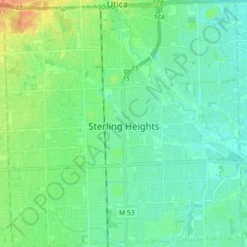
Name: Sterling Heights topographic map, elevation, terrain.
Location: Sterling Heights, Macomb County, Michigan, United States (42.53479 -83.09151 42.62753 -82.96964)
Average elevation: 191 m
Minimum elevation: 181 m
Maximum elevation: 215 m
Other topographic maps
Click on a map to view its topography, its elevation and its terrain.
Sterling Heights
United States > Michigan > Macomb County > Sterling Heights > Sterling Heights
Average elevation: 205 m
Shelby Charter Township
United States > Michigan > Macomb County > Shelby Charter Township
Average elevation: 205 m