Geolocate

Ocean Pines topographic map

Interactive map

Click on the map to display elevation.

About this map

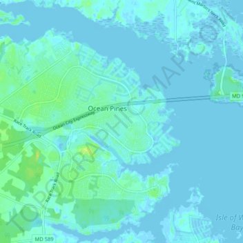
Name: Ocean Pines topographic map, elevation, terrain.

Location: Ocean Pines, Worcester County, Maryland, United States (38.35395 -75.18603 38.40950 -75.10656)

Average elevation: 3 m

Minimum elevation: -4 m

Maximum elevation: 17 m

Other topographic maps

Click on a map to view its topography, its elevation and its terrain.

West Ocean City

United States > Maryland > Worcester County > West Ocean City

West Ocean City, Worcester County, Maryland, United States

Average elevation: 2 m

Ocean City

United States > Maryland > Worcester County

Ocean City, Worcester County, Maryland, United States

Average elevation: 1 m

Stockton

United States > Maryland > Worcester County > Stockton

Stockton, Worcester County, Maryland, United States

Average elevation: 8 m

Snow Hill

United States > Maryland > Worcester County

Snow Hill, Worcester County, Maryland, United States

Average elevation: 7 m

Assateague Island National Seashore

United States > Maryland > Worcester County > West Ocean City

Assateague Island National Seashore, West Ocean City, Worcester County, Maryland, United States

Average elevation: 2 m

Newark

United States > Maryland > Worcester County > Newark

Newark, Worcester County, Maryland, United States

Average elevation: 10 m

Worcester County

United States > Maryland > Worcester County

Worcester County, Maryland, United States

Average elevation: 6 m