
Kirkkonummi topographic map
Interactive map
Click on the map to display elevation.
About this map
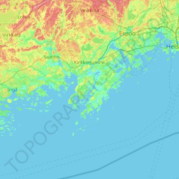
Name: Kirkkonummi topographic map, elevation, terrain.
Average elevation: 15 m
Minimum elevation: -3 m
Maximum elevation: 119 m
Other topographic maps
Click on a map to view its topography, its elevation and its terrain.
Lilla Rågholmen
Finland > Uusimaa > Kirkkonummi > Hirsala
Lilla Rågholmen, Hirsala, Itäinen Kirkkonummi, Kirkkonummi, Helsinki sub-region, Uusimaa, Southern Finland, Mainland Finland, Finland
Average elevation: 4 m