
Stephenson Nature Preserve And Outdoor Education Center topographic map
Interactive map
Click on the map to display elevation.
About this map
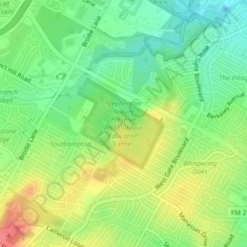
Name: Stephenson Nature Preserve And Outdoor Education Center topographic map, elevation, terrain.
Average elevation: 230 m
Minimum elevation: 201 m
Maximum elevation: 268 m
Other topographic maps
Click on a map to view its topography, its elevation and its terrain.
Balcones District Park
Balcones District Park, 12017, North Loop Business Park, Austin, Travis County, Texas, 78759, USA
Average elevation: 235 m
Jollyville Plateau
Jollyville Plateau, Austin, Travis County, Texas, 78726, USA
Average elevation: 297 m
Red Bud Isle
Red Bud Isle, Austin, Travis County, Texas, USA
Average elevation: 181 m