
Port Erin topographic map
Interactive map
Click on the map to display elevation.
About this map
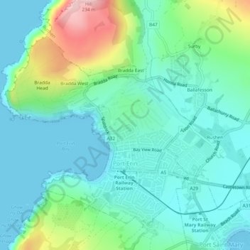
Name: Port Erin topographic map, elevation, terrain.
Location: Port Erin, Rushen, Isle of Man (54.07950 -4.77979 54.10075 -4.74466)
Average elevation: 52 m
Minimum elevation: 0 m
Maximum elevation: 221 m
Other topographic maps
Click on a map to view its topography, its elevation and its terrain.
Silverburn
Isle of Man > Rushen > Malew > Ballasalla
Silverburn, Ballasalla, Malew, Rushen, Isle of Man
Average elevation: 20 m