
Žabljak topographic map
Interactive map
Click on the map to display elevation.
About this map
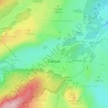
Name: Žabljak topographic map, elevation, terrain.
Location: Žabljak, Žabljak Municipality, Montenegro (43.14895 19.10998 43.16449 19.13694)
Average elevation: 1,461 m
Minimum elevation: 1,378 m
Maximum elevation: 1,604 m
Žabljak is the seat of Žabljak Municipality (2011 population: 3,569). The town is in the centre of the Durmitor mountain region and with an altitude of 1,456 metres, it is the highest situated Balkan town.
Other topographic maps
Click on a map to view its topography, its elevation and its terrain.
Tara Canyon
Montenegro > Žabljak Municipality > Bosača > Jablan bara
Tara Canyon, Jablan bara, Bosača, Žabljak Municipality, Montenegro
Average elevation: 1,644 m
Bobotov Kuk
Montenegro > Žabljak Municipality
Bobotov Kuk, Žabljak Municipality, Montenegro
Average elevation: 2,084 m
Durmitor
Montenegro > Žabljak Municipality
Durmitor, Žabljak Municipality, 84220, Montenegro
Average elevation: 1,953 m