
Kupang topographic map
Interactive map
Click on the map to display elevation.
About this map
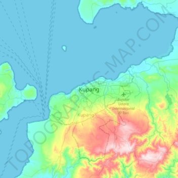
Name: Kupang topographic map, elevation, terrain.
Location: Kupang, East Nusa Tenggara, 85001, Indonesia (-10.32322 123.44178 -10.00322 123.76178)
Average elevation: 90 m
Minimum elevation: 0 m
Maximum elevation: 502 m
Other topographic maps
Click on a map to view its topography, its elevation and its terrain.
Kayu Putih
Indonesia > East Nusa Tenggara > Kupang
Kayu Putih, Kupang, East Nusa Tenggara, Lesser Sunda Islands, 85116, Indonesia
Average elevation: 75 m