
Waldsassen topographic map
Interactive map
Click on the map to display elevation.
About this map
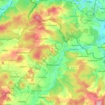
Name: Waldsassen topographic map, elevation, terrain.
Location: Waldsassen, Landkreis Tirschenreuth, Bavaria, 95652, Germany (49.97811 12.23226 50.06136 12.42407)
Average elevation: 533 m
Minimum elevation: 433 m
Maximum elevation: 684 m
Other topographic maps
Click on a map to view its topography, its elevation and its terrain.
Wiesau
Germany > Bavaria > Landkreis Tirschenreuth > Wiesau
Wiesau, Wiesau (VGem), Landkreis Tirschenreuth, Bavaria, 95676, Germany
Average elevation: 528 m
Waldershof
Germany > Bavaria > Landkreis Tirschenreuth
Waldershof, Landkreis Tirschenreuth, Bavaria, 95679, Germany
Average elevation: 637 m