
Gitega topographic map
Interactive map
Click on the map to display elevation.
About this map
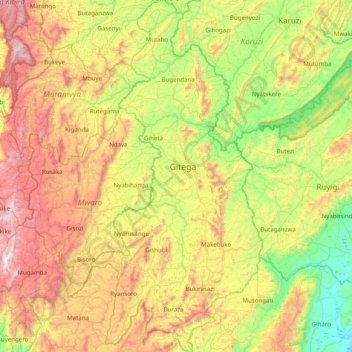
Name: Gitega topographic map, elevation, terrain.
Location: Gitega, Burundi (-3.84467 29.71741 -3.05661 30.10402)
Average elevation: 1,733 m
Minimum elevation: 1,152 m
Maximum elevation: 2,667 m
Other topographic maps
Click on a map to view its topography, its elevation and its terrain.
Rukuba
Burundi > Bujumbura Rural Province
Rukuba, Bujumbura Rural Province, Burundi
Average elevation: 1,288 m