
Basel-City topographic map
Interactive map
Click on the map to display elevation.
About this map
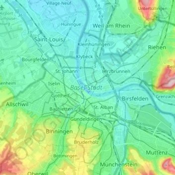
Name: Basel-City topographic map, elevation, terrain.
Location: Basel-City, Switzerland (47.51929 7.55466 47.60091 7.69379)
Average elevation: 291 m
Minimum elevation: 242 m
Maximum elevation: 476 m
Other topographic maps
Click on a map to view its topography, its elevation and its terrain.
Bern
Switzerland > Bern > Bern-Mittelland administrative district
Bern, Bern-Mittelland administrative district, Bernese Mittelland administrative region, Bern, Switzerland
Average elevation: 612 m
Zurich
Switzerland > Zurich > District Zurich
Zurich, District Zurich, Zurich, Switzerland
Average elevation: 499 m
Sisseln
Switzerland > Aargau > Bezirk Laufenburg
Sisseln, Bezirk Laufenburg, Aargau, 4334, Switzerland
Average elevation: 323 m
Kaiseraugst
Switzerland > Aargau > Bezirk Rheinfelden
Kaiseraugst, Bezirk Rheinfelden, Aargau, 4303, Switzerland
Average elevation: 293 m
Thörishaus
Switzerland > Bern > Bern-Mittelland administrative district > Köniz
Thörishaus, Köniz, Bern-Mittelland administrative district, Bernese Mittelland administrative region, Bern, 3174, Switzerland
Average elevation: 653 m
Matterhorn
Switzerland > Wallis > Visp > Zermatt
Matterhorn, Zermatt, Visp, Wallis, 3920, Switzerland
Average elevation: 3,295 m
Wacht
Switzerland > Zurich > Bezirk Hinwil > Rüti (ZH)
Wacht, Rüti (ZH), Bezirk Hinwil, Zurich, 8630, Switzerland
Average elevation: 511 m
Surcuolm
Switzerland > Grisons > Surselva > Obersaxen-Mundaun
Surcuolm, Obersaxen-Mundaun, Surselva, Grisons, 7138, Switzerland
Average elevation: 1,311 m
Zermatt
Switzerland > Wallis > Visp
Zermatt, Visp, Wallis, 3920, Switzerland
Average elevation: 2,921 m
Saint-Blaise
Saint-Blaise, Neuchâtel, 2072, Switzerland
Average elevation: 687 m
Cossonay
Switzerland > Vaud > District de Morges
Cossonay, District de Morges, Vaud, 1304, Switzerland
Average elevation: 533 m
Oberriet
Switzerland > St. Gallen > Wahlkreis Rheintal
Oberriet, Wahlkreis Rheintal, St. Gallen, Switzerland
Average elevation: 528 m
Davosersee
Switzerland > Grisons > Prättigau/Davos > Davos
Davosersee, Davos Dorf, Davos, Prättigau/Davos, Grisons, Switzerland
Average elevation: 1,722 m
Abtwil
Switzerland > Aargau > Bezirk Muri
Abtwil, Bezirk Muri, Aargau, 5646, Switzerland
Average elevation: 539 m
Konolfingen
Switzerland > Bern > Bern-Mittelland administrative district
Konolfingen, Bern-Mittelland administrative district, Bernese Mittelland administrative region, Bern, Switzerland
Average elevation: 745 m
Uitikon
Switzerland > Zurich > Bezirk Dietikon
Uitikon, Bezirk Dietikon, Zurich, 8142, Switzerland
Average elevation: 542 m
Bignasco
Switzerland > Ticino > Distretto di Vallemaggia
Bignasco, Cevio, Circolo della Rovana, Distretto di Vallemaggia, Ticino, 6676, Switzerland
Average elevation: 956 m
Les Maresses
Switzerland > Wallis > Hérens > Mont-Noble > Vernamiège
Les Maresses, Vernamiège, Mont-Noble, Hérens, Wallis, 1961, Switzerland
Average elevation: 1,657 m
Laufen
Switzerland > Basel-Landschaft > Bezirk Laufen
Laufen, Bezirk Laufen, Basel-Landschaft, 4242, Switzerland
Average elevation: 455 m
Morrens
Switzerland > Vaud > District du Gros-de-Vaud
Morrens, District du Gros-de-Vaud, Vaud, 1054, Switzerland
Average elevation: 672 m
Wallisellen
Switzerland > Zurich > Bezirk Bülach
Wallisellen, Bezirk Bülach, Zurich, Switzerland
Average elevation: 451 m
Pied de Ville
Switzerland > Wallis > Entremont > Sembrancher
Pied de Ville, La Gravenne, Sembrancher, Entremont, Wallis, 2303, Switzerland
Average elevation: 960 m
Gletterens
Switzerland > Fribourg > District de la Broye
Gletterens, District de la Broye, Fribourg, 1544, Switzerland
Average elevation: 464 m
Drapel
Switzerland > Vaud > District d'Aigle > Aigle
Drapel, Aigle, District d'Aigle, Vaud, 1860, Switzerland
Average elevation: 716 m
Lac de Chermignon
Switzerland > Wallis > Sierre > Plans-Mayens
Lac de Chermignon, Plans-Mayens, Lens, Sierre, Wallis, 3960, Switzerland
Average elevation: 1,548 m
Gähwil
Switzerland > St. Gallen > Wahlkreis Toggenburg > Kirchberg (SG)
Gähwil, Kirchberg (SG), Wahlkreis Toggenburg, St. Gallen, 9534, Switzerland
Average elevation: 778 m
Büel
Switzerland > Grisons > Viamala > Avers
Büel, Avers, Viamala, Grisons, 7447, Switzerland
Average elevation: 2,648 m
Hospental
Switzerland > Uri > Korporation Ursern
Hospental, Korporation Ursern, Uri, 6493, Switzerland
Average elevation: 2,144 m
Hochwald
Switzerland > Solothurn > Amtei Dorneck-Thierstein
Hochwald, Bezirk Dorneck, Amtei Dorneck-Thierstein, Solothurn, 4146, Switzerland
Average elevation: 615 m
Schloss Meggenhorn
Switzerland > Lucerne > Meggen
Schloss Meggenhorn, 53, Meggenhornstrasse, Lerchenbühl, Meggen, Lucerne, 6045, Switzerland
Average elevation: 450 m
Braunwald
Switzerland > Glarus > Glarus Süd
Braunwald, Glarus Süd, Glarus, 8784, Switzerland
Average elevation: 1,215 m
Baule
Switzerland > Wallis > Hérens > Saint-Martin (VS) > St-Martin VS
Baule, St-Martin VS, Saint-Martin (VS), Hérens, Wallis, 1969, Switzerland
Average elevation: 1,439 m
Lützelflüh
Switzerland > Bern > Emmental administrative district
Lützelflüh, Emmental administrative district, Emmental-Oberaargau administrative region, Bern, Switzerland
Average elevation: 730 m
Langenthal
Switzerland > Bern > Oberaargau administrative district
Langenthal, Oberaargau administrative district, Emmental-Oberaargau administrative region, Bern, Switzerland
Average elevation: 497 m
Berneck
Switzerland > St. Gallen > Wahlkreis Rheintal
Berneck, Wahlkreis Rheintal, St. Gallen, 9442, Switzerland
Average elevation: 561 m
Yverdon-les-Bains
Switzerland > Vaud > District du Jura-Nord vaudois
Yverdon-les-Bains, District du Jura-Nord vaudois, Vaud, Switzerland
Average elevation: 480 m
Raviscé
Switzerland > Grisons > Bernina > San Carlo
Raviscé, San Carlo, Poschiavo, Bernina, Grisons, 7741, Switzerland
Average elevation: 1,529 m
Glattfelden
Switzerland > Zurich > Bezirk Bülach
Glattfelden, Bezirk Bülach, Zurich, 8192, Switzerland
Average elevation: 413 m
Saillon
Switzerland > Wallis > Martigny
Saillon, Martigny, Wallis, 1913, Switzerland
Average elevation: 975 m
Arlesheim
Switzerland > Basel-Landschaft > Bezirk Arlesheim
Arlesheim, Bezirk Arlesheim, Basel-Landschaft, 4144, Switzerland
Average elevation: 379 m
Mettmenstetten
Switzerland > Zurich > Bezirk Affoltern
Mettmenstetten, Bezirk Affoltern, Zurich, 8932, Switzerland
Average elevation: 506 m
Salmsach
Switzerland > Thurgau > Bezirk Arbon
Salmsach, Bezirk Arbon, Thurgau, 8599, Switzerland
Average elevation: 413 m
Les Posettes
Switzerland > Wallis > Entremont > Vollèges > Charançon
Les Posettes, Charançon, Vollèges, Val de Bagnes, Entremont, Wallis, 1934, Switzerland
Average elevation: 1,010 m
Binz
Switzerland > Zurich > Bezirk Uster
Binz, Maur, Bezirk Uster, Zurich, 8122, Switzerland
Average elevation: 592 m
Herrenschwanden
Switzerland > Bern > Bern-Mittelland administrative district
Herrenschwanden, Kirchlindach, Bern-Mittelland administrative district, Bernese Mittelland administrative region, Bern, 3037, Switzerland
Average elevation: 560 m
Meinisberg
Switzerland > Bern > Biel/Bienne administrative district
Meinisberg, Biel/Bienne administrative district, Seeland administrative region, Bern, 2554, Switzerland
Average elevation: 455 m
Hinteralbis
Switzerland > Zurich > Bezirk Horgen > Langnau am Albis
Hinteralbis, Langnau am Albis, Bezirk Horgen, Zurich, 8135, Switzerland
Average elevation: 688 m