
Village of Fort Edward topographic map
Interactive map
Click on the map to display elevation.
About this map
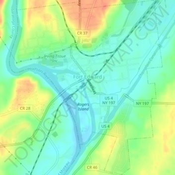
Name: Village of Fort Edward topographic map, elevation, terrain.
Average elevation: 52 m
Minimum elevation: 34 m
Maximum elevation: 83 m
Other topographic maps
Click on a map to view its topography, its elevation and its terrain.
Bald Mountain
United States > New York > Washington County
Bald Mountain, Washington County, New York, United States
Average elevation: 261 m
Village of Cambridge
United States > New York > Washington County
Village of Cambridge, Town of White Creek, Washington County, New York, United States
Average elevation: 165 m
Town of Dresden
United States > New York > Washington County
Town of Dresden, Washington County, New York, United States
Average elevation: 249 m
Black Mountain
United States > New York > Washington County
Black Mountain, Town of Dresden, Washington County, New York, 12841, United States
Average elevation: 487 m
West Hebron
United States > New York > Washington County > West Hebron
West Hebron, Town of Hebron, Washington County, New York, 12865, United States
Average elevation: 209 m
Putnam Station
United States > New York > Washington County > Putnam Station
Putnam Station, Town of Putnam, Washington County, New York, United States
Average elevation: 83 m
West Cambridge
United States > New York > Washington County > Town of Cambridge
West Cambridge, Town of Cambridge, Washington County, New York, United States
Average elevation: 199 m