
Chickamauga topographic map
Interactive map
Click on the map to display elevation.
About this map
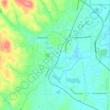
Name: Chickamauga topographic map, elevation, terrain.
Location: Chickamauga, Walker County, Georgia, United States (34.86056 -85.31627 34.89152 -85.26424)
Average elevation: 238 m
Minimum elevation: 212 m
Maximum elevation: 303 m
Other topographic maps
Click on a map to view its topography, its elevation and its terrain.
White Oak
United States > Georgia > Walker County
White Oak, Walker County, Georgia, 30741, United States
Average elevation: 249 m
LaFayette
United States > Georgia > Walker County > LaFayette
LaFayette, Walker County, Georgia, United States
Average elevation: 276 m