
Chillicothe topographic map
Interactive map
Click on the map to display elevation.
About this map
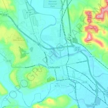
Name: Chillicothe topographic map, elevation, terrain.
Location: Chillicothe, Ross County, Ohio, 45601, United States (39.31293 -83.05398 39.37385 -82.94527)
Average elevation: 217 m
Minimum elevation: 177 m
Maximum elevation: 385 m
Other topographic maps
Click on a map to view its topography, its elevation and its terrain.
Austin
United States > Ohio > Ross County > Austin
Austin, Ross County, Ohio, 43115:45123:45628, United States
Average elevation: 245 m