
Werlaburgdorf topographic map
Interactive map
Click on the map to display elevation.
About this map
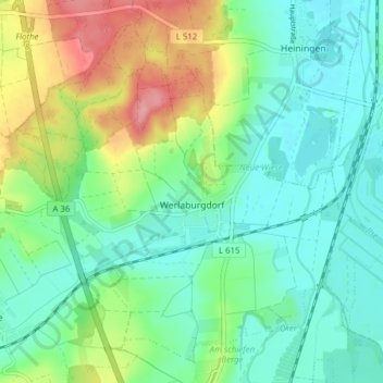
Name: Werlaburgdorf topographic map, elevation, terrain.
Average elevation: 112 m
Minimum elevation: 79 m
Maximum elevation: 188 m
Other topographic maps
Click on a map to view its topography, its elevation and its terrain.
Abbenrode
Germany > Lower Saxony > Landkreis Wolfenbüttel > Cremlingen
Abbenrode, Cremlingen, Landkreis Wolfenbüttel, Lower Saxony, Germany
Average elevation: 160 m
Veltheim
Germany > Lower Saxony > Landkreis Wolfenbüttel
Veltheim, Samtgemeinde Sickte, Landkreis Wolfenbüttel, Lower Saxony, Germany
Average elevation: 132 m
Werlaburgdorf
Germany > Lower Saxony > Landkreis Wolfenbüttel > Werlaburgdorf
Werlaburgdorf, Landkreis Wolfenbüttel, Lower Saxony, 38315, Germany
Average elevation: 111 m
Elbe
Germany > Lower Saxony > Landkreis Wolfenbüttel
Elbe, Samtgemeinde Baddeckenstedt, Landkreis Wolfenbüttel, Lower Saxony, 38274, Germany
Average elevation: 142 m