
Villaconejos topographic map
Interactive map
Click on the map to display elevation.
About this map
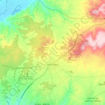
Name: Villaconejos topographic map, elevation, terrain.
Location: Villaconejos, Las Vegas, Community of Madrid, 28360, Spain (40.08486 -3.54951 40.13998 -3.45111)
Average elevation: 628 m
Minimum elevation: 510 m
Maximum elevation: 778 m
Other topographic maps
Click on a map to view its topography, its elevation and its terrain.
San Martín de la Vega
Spain > Community of Madrid > Las Vegas > San Martín de la Vega
San Martín de la Vega, Las Vegas, Community of Madrid, 28330, Spain
Average elevation: 585 m
Morata de Tajuña
Spain > Community of Madrid > Las Vegas
Morata de Tajuña, Las Vegas, Community of Madrid, 28530, Spain
Average elevation: 650 m