
Tooele County topographic map
Interactive map
Click on the map to display elevation.
About this map
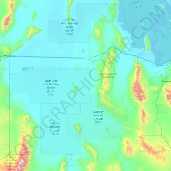
Name: Tooele County topographic map, elevation, terrain.
Location: Tooele County, Utah, United States (39.90335 -114.04838 41.07684 -112.14425)
Average elevation: 1,463 m
Minimum elevation: 1,279 m
Maximum elevation: 3,633 m
Tooele County lies on the west side of Utah. Its west border abuts the east border of the state of Nevada. Its northeast border abuts the Great Salt Lake. Three significant mountain ranges run north–south through the county. Its east boundary line is delineated by the crestline of the Oquirrh Mountains, which separate the Tooele Valley from the Salt Lake Valley. The Stansbury Mountains parallel the Oquirrhs in the eastern part of the county, and the Cedar Mountains also run parallel to the other two through the east-central part of the county. There are also isolated prominences across the county, especially at its SW corner. The county terrain is largely arid and unused for agriculture unless irrigation water is available. The county generally slopes to the north. Its highest elevation is Deseret Peak in the Stansburys, at 11,031' (3362m) ASL. The county has a total area of 7,286 square miles (18,870 km2), of which 6,941 square miles (17,980 km2) is land and 345 square miles (890 km2) (4.7%) is water.
Other topographic maps
Click on a map to view its topography, its elevation and its terrain.
Ogden
United States > Utah > Weber County
Ogden, Weber County, Utah, United States
Average elevation: 1,498 m
Provo
United States > Utah > Utah County
Provo, Utah County, Utah, United States
Average elevation: 1,728 m
Cedar City
United States > Utah > Iron County
Cedar City, Iron County, Utah, United States
Average elevation: 1,975 m
Park City
United States > Utah > Summit County
Park City, Summit County, Utah, United States
Average elevation: 2,290 m
Moab
United States > Utah > Grand County
Moab, Grand County, Utah, 84532, United States
Average elevation: 1,357 m
Farr West
United States > Utah > Weber County
Farr West, Weber County, Utah, United States
Average elevation: 1,313 m
Fruitland
United States > Utah > Duchesne County
Fruitland, Duchesne County, Utah, 84027, United States
Average elevation: 2,028 m
Saratoga Springs
United States > Utah > Utah County
Saratoga Springs, Utah County, Utah, 84045, United States
Average elevation: 1,500 m
Mount Timpanogos
United States > Utah > Utah County
Mount Timpanogos, Utah County, Utah, 84602, United States
Average elevation: 3,139 m
Echo
United States > Utah > Summit County
Echo, Summit County, Utah, 84024, United States
Average elevation: 1,792 m
Elk Ridge
United States > Utah > Utah County
Elk Ridge, Utah County, Utah, United States
Average elevation: 1,698 m
Springdale
United States > Utah > Washington County
Springdale, Washington County, Utah, 84767, United States
Average elevation: 1,354 m
Malad River
United States > Utah > Box Elder County
Malad River, Box Elder County, Utah, 84301, United States
Average elevation: 1,295 m
Draper
United States > Utah > Salt Lake County
Draper, Salt Lake County, Utah, 84020, United States
Average elevation: 1,573 m
Bel-Mar Acres
United States > Utah > Weber County > South Ogden
Bel-Mar Acres, South Ogden, Weber County, Utah, 84408, United States
Average elevation: 1,375 m
Upheaval Dome
United States > Utah > San Juan County
Upheaval Dome, San Juan County, Utah, United States
Average elevation: 1,627 m
Bryce Canyon National Park
United States > Utah > Garfield County
Bryce Canyon National Park, Garfield County, Utah, United States
Average elevation: 2,259 m
Halchita
United States > Utah > San Juan County
Halchita, San Juan County, Utah, United States
Average elevation: 1,398 m
Price
United States > Utah > Carbon County
Price, Carbon County, Utah, 84591, United States
Average elevation: 1,711 m
Centerville
United States > Utah > Davis County
Centerville, Davis County, Utah, 84014, United States
Average elevation: 1,521 m
Washington County
Washington County, Utah, United States
Average elevation: 1,550 m
Riverton
United States > Utah > Salt Lake County
Riverton, Salt Lake County, Utah, United States
Average elevation: 1,376 m
Townsend
United States > Utah > Utah County > Genola
Townsend, Genola, Utah County, Utah, 84655, United States
Average elevation: 1,438 m
Manns Peak
United States > Utah > Grand County
Manns Peak, Grand County, Utah, United States
Average elevation: 3,427 m
Castle Valley
United States > Utah > Grand County
Castle Valley, Grand County, Utah, United States
Average elevation: 1,610 m
Castleton Tower
United States > Utah > Grand County
Castleton Tower, Grand County, Utah, United States
Average elevation: 1,549 m
Black Mountain
United States > Utah > Salt Lake County > Salt Lake City
Black Mountain, Salt Lake City, Salt Lake County, Utah, United States
Average elevation: 2,250 m
Black Mountain
United States > Utah > Rich County
Black Mountain, Rich County, Utah, United States
Average elevation: 2,157 m
Salina
United States > Utah > Sevier County
Salina, Sevier County, Utah, 84654, United States
Average elevation: 1,637 m
Pleasant View
United States > Utah > Utah County > Provo
Pleasant View, Provo, Utah County, Utah, 84604, United States
Average elevation: 1,446 m
Summit Park
United States > Utah > Summit County
Summit Park, Summit County, Utah, United States
Average elevation: 2,152 m
Colorado Plateau
United States > Utah > San Juan County
Colorado Plateau, San Juan County, Utah, United States
Average elevation: 1,512 m
Coalville
United States > Utah > Summit County
Coalville, Summit County, Utah, United States
Average elevation: 1,825 m
Heber
United States > Utah > Wasatch County
Heber, Wasatch County, Utah, 84032, United States
Average elevation: 1,737 m
Mountains Meadows
United States > Utah > Davis County > North Salt Lake
Mountains Meadows, North Salt Lake, Davis County, Utah, 84054, United States
Average elevation: 1,411 m
West Haven
United States > Utah > Weber County
West Haven, Weber County, Utah, United States
Average elevation: 1,310 m
Holladay
United States > Utah > Salt Lake County
Holladay, Salt Lake County, Utah, 84124, United States
Average elevation: 1,425 m
Saint George
United States > Utah > Washington County
Saint George, Washington County, Utah, United States
Average elevation: 929 m
Salt Lake City
United States > Utah > Salt Lake County
Salt Lake City, Salt Lake County, Utah, United States
Average elevation: 1,592 m
Aneth
United States > Utah > San Juan County
Aneth, Shiprock Agency, San Juan County, Utah, United States
Average elevation: 1,422 m
South Jordan
United States > Utah > Salt Lake County
South Jordan, Salt Lake County, Utah, 84095, United States
Average elevation: 1,407 m
Salem
United States > Utah > Utah County
Salem, Utah County, Utah, 84653, United States
Average elevation: 1,473 m
Meridian Peak
United States > Utah > Salt Lake County > Salt Lake City
Meridian Peak, Salt Lake City, Salt Lake County, Utah, 84143, United States
Average elevation: 1,698 m