
Make a donation
Gear up for your next adventure:
As an Amazon Associate, this site earns from qualifying purchases at no extra cost to you.
Parco Regionale dei Monti Picentini topographic map
Click on the map to display elevation.
Make a donation
Gear up for your next adventure:
As an Amazon Associate, this site earns from qualifying purchases at no extra cost to you.
About this map
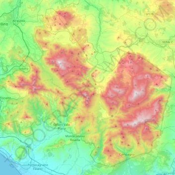
Name: Parco Regionale dei Monti Picentini topographic map, elevation, terrain.
Location: Parco Regionale dei Monti Picentini, Avellino, Campania, Italy (40.64027 14.77867 40.94463 15.22155)
Average elevation: 646 m
Minimum elevation: 0 m
Maximum elevation: 1,802 m
Make a donation
Gear up for your next adventure:
As an Amazon Associate, this site earns from qualifying purchases at no extra cost to you.
Other topographic maps
Click on a map to view its topography, its elevation and its terrain.
Make a donation
Gear up for your next adventure:
As an Amazon Associate, this site earns from qualifying purchases at no extra cost to you.
Montecalvo Irpino
Montecalvo Irpino is located in the northern sector of the province of Avellino, on the border with Benevento. The municipality, built at an elevation of 2,044 ft (623 m) MSL, upstream of the confluence between the Miscano stream and the Ufita River, is part of the mountain community of Ufita. Its land is…
Average elevation: 497 m
Make a donation
Gear up for your next adventure:
As an Amazon Associate, this site earns from qualifying purchases at no extra cost to you.
Make a donation
Gear up for your next adventure:
As an Amazon Associate, this site earns from qualifying purchases at no extra cost to you.
Ariano Irpino
At an elevation of 788 metres (2,585 ft) above sea level, Ariano Irpino is centered between the Adriatic Sea and the Tyrrhenian Sea. It is 39 km east of Benevento, 51 km north-east of Avellino and 62 km south-west of Foggia.
Average elevation: 511 m
Make a donation
Gear up for your next adventure:
As an Amazon Associate, this site earns from qualifying purchases at no extra cost to you.
Make a donation
Gear up for your next adventure:
As an Amazon Associate, this site earns from qualifying purchases at no extra cost to you.