
Parco Regionale dei Monti Picentini topographic map
Interactive map
Click on the map to display elevation.
About this map
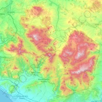
Name: Parco Regionale dei Monti Picentini topographic map, elevation, terrain.
Location: Parco Regionale dei Monti Picentini, Avellino, Campania, Italy (40.64027 14.77867 40.94463 15.22155)
Average elevation: 646 m
Minimum elevation: 0 m
Maximum elevation: 1,802 m
Other topographic maps
Click on a map to view its topography, its elevation and its terrain.
Ariano Irpino
At an elevation of 788 metres (2,585 ft) above sea level, Ariano Irpino is centered between the Adriatic Sea and the Tyrrhenian Sea. It is 39 km east of Benevento, 51 km north-east of Avellino and 62 km south-west of Foggia.
Average elevation: 511 m