
Asutsuare topographic map
Interactive map
Click on the map to display elevation.
About this map
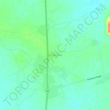
Name: Asutsuare topographic map, elevation, terrain.
Location: Asutsuare, Shai-Osudoku District, Greater Accra Region, Ghana (5.97234 0.03638 6.01234 0.07638)
Average elevation: 62 m
Minimum elevation: 44 m
Maximum elevation: 117 m
Other topographic maps
Click on a map to view its topography, its elevation and its terrain.
Mount Osodoku
Ghana > Greater Accra Region > Shai-Osudoku District
Mount Osodoku, Shai-Osudoku District, Greater Accra Region, Ghana
Average elevation: 88 m
Dodowa
Ghana > Greater Accra Region > Shai-Osudoku District
Dodowa, Shai-Osudoku District, Greater Accra Region, Ghana
Average elevation: 127 m