
Highcliffe Castle topographic map
Interactive map
Click on the map to display elevation.
About this map
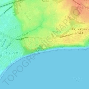
Name: Highcliffe Castle topographic map, elevation, terrain.
Average elevation: 13 m
Minimum elevation: 0 m
Maximum elevation: 39 m
Other topographic maps
Click on a map to view its topography, its elevation and its terrain.
Highcliffe and Walkford
United Kingdom > England > Highcliffe-on-Sea
Highcliffe and Walkford, Highcliffe-on-Sea, Bournemouth, Christchurch and Poole, South West England, England, United Kingdom
Average elevation: 17 m
Christchurch Bay
United Kingdom > England > Highcliffe-on-Sea
Christchurch Bay, Wharncliffe Road, Highcliffe and Walkford, Highcliffe-on-Sea, Bournemouth, Christchurch and Poole, South West England, England, BH23 5UA, United Kingdom
Average elevation: 4 m