
Passo Fundo topographic map
Interactive map
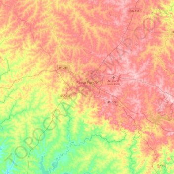
Click on the map to display elevation.
About this map
Name: Passo Fundo topographic map, elevation, terrain.
Average elevation: 616 m
Minimum elevation: 442 m
Maximum elevation: 774 m
Lying near latitude 28° at an elevation of 690 m (2,263.8 ft), Passo Fundo has a humid subtropical climate. The annual mean temperature is 17.7° C (63.9° F) with highs of 28.4° C (83.1° F) in January and 18.3° C (64.9° F) in July and lows of 17.7° C (63.9° F) in January and 8.8° C (47.8° F) in July. Winters can be slightly cool with temperatures below 0° C (32° F), frequent frosts and occasional snowfalls. Rainfall is spread out throughout the year with September receiving the highest amount of 183.4 mm (7.2 in) and May receiving the lowest amount of 133.5 mm (5.3 in). Humidity is around 70% every month.
Other topographic maps
Click on a map to view its topography, its elevation and its terrain.
São Roque
Brazil > Rio Grande do Sul > Passo Fundo
São Roque, Passo Fundo, Região Geográfica Imediata de Passo Fundo, Região Geográfica Intermediária de Passo Fundo, Rio Grande do Sul, South Region, Brazil
Average elevation: 591 m