
Hrochoť topographic map
Interactive map
Click on the map to display elevation.
About this map
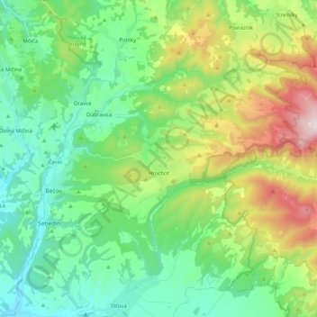
Name: Hrochoť topographic map, elevation, terrain.
Average elevation: 597 m
Minimum elevation: 324 m
Maximum elevation: 1,263 m
Other topographic maps
Click on a map to view its topography, its elevation and its terrain.
Hrochoť
Slovakia > Region of Banská Bystrica > District of Banská Bystrica > Hrochoť > Hrochoť
Hrochoť, District of Banská Bystrica, Region of Banská Bystrica, Central Slovakia, 976 37, Slovakia
Average elevation: 626 m
Banská Bystrica
Slovakia > Region of Banská Bystrica > District of Banská Bystrica
Banská Bystrica, District of Banská Bystrica, Region of Banská Bystrica, Central Slovakia, Slovakia
Average elevation: 566 m
Japeň
Slovakia > Region of Banská Bystrica > District of Banská Bystrica > Dolný Harmanec
Japeň, Dolný Harmanec, District of Banská Bystrica, Region of Banská Bystrica, Central Slovakia, 976 03, Slovakia
Average elevation: 745 m