
Tinos topographic map
Interactive map
Click on the map to display elevation.
Tinos
Tinos has a varied landscape. From the shores of Panormos and Kolimbithra on the North Shore to Kionia, Agios Yannis O Portos, and Agios Sostis on the Southern Shore, Tinos has many beaches. Tsiknias is the highest mountain on the island at 750 metres (2,460 feet) and hides the village of Livada. The mountain of Exobourgo is quite distinct, and unlike its more rounded Cycladic neighbors, has a jagged appearance that would be more at home in the Alps. Between Tsiknias and Exobourgo lies the fruitful plain of Falatados. This area is unique on the island as its relatively flat terrain (albeit with an elevation of about 300 metres (980 feet)) is rare on the island. This made it a strong candidate for a proposed airport on the island. The Meltemi winds and concerns of local villagers of the towns of Falatados, and Steni have all but halted the project.
About this map
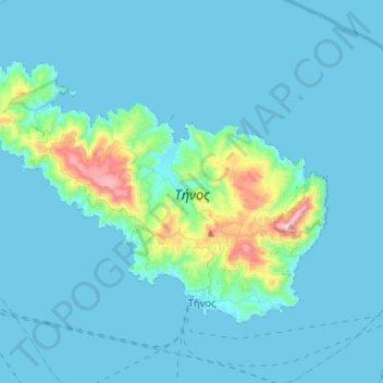
Name: Tinos topographic map, elevation, terrain.
Location: Tinos, Tinos Regional Unit, South Aegean, Aegean, Greece (37.52477 24.97211 37.67858 25.25427)
Average elevation: 64 m
Minimum elevation: 0 m
Maximum elevation: 702 m