
Thank you for supporting this site ❤️
Make a donation
Make a donation
Gear up for your next adventure:
As an Amazon Associate, this site earns from qualifying purchases at no extra cost to you.
Long Điền topographic map
Click on the map to display elevation.
Thank you for supporting this site ❤️
Make a donation
Make a donation
Gear up for your next adventure:
As an Amazon Associate, this site earns from qualifying purchases at no extra cost to you.
About this map
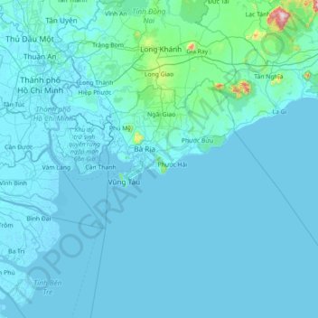
Name: Long Điền topographic map, elevation, terrain.
Location: Long Điền, Ba Ria-Vung Tau Province, Vietnam (9.74727 106.53354 11.14727 107.93354)
Average elevation: 33 m
Minimum elevation: -4 m
Maximum elevation: 1,236 m
Thank you for supporting this site ❤️
Make a donation
Make a donation
Gear up for your next adventure:
As an Amazon Associate, this site earns from qualifying purchases at no extra cost to you.
Other topographic maps
Click on a map to view its topography, its elevation and its terrain.
Dat Do Town
Vietnam > Ba Ria-Vung Tau Province > Dat Do District > Dat Do Town
Average elevation: 16 m