
Long Điền topographic map
Interactive map
Click on the map to display elevation.
About this map
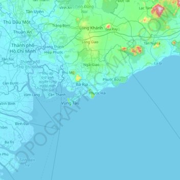
Name: Long Điền topographic map, elevation, terrain.
Location: Long Điền, Ba Ria-Vung Tau Province, Vietnam (9.74727 106.53354 11.14727 107.93354)
Average elevation: 33 m
Minimum elevation: -4 m
Maximum elevation: 1,236 m
Other topographic maps
Click on a map to view its topography, its elevation and its terrain.
Dat Do Town
Vietnam > Ba Ria-Vung Tau Province > Dat Do District > Dat Do Town
Dat Do Town, Dat Do District, Ba Ria-Vung Tau Province, 0643, Vietnam
Average elevation: 16 m
Tân Lâm Commune
Vietnam > Ba Ria-Vung Tau Province > Tân Lâm Commune
Tân Lâm Commune, Xuyên Mộc District, Ba Ria-Vung Tau Province, Vietnam
Average elevation: 100 m
Côn Sơn Island
Vietnam > Ba Ria-Vung Tau Province
Côn Sơn Island, Côn Đảo, Ba Ria-Vung Tau Province, Vietnam
Average elevation: 2 m