
Hillsborough topographic map
Interactive map
Click on the map to display elevation.
About this map
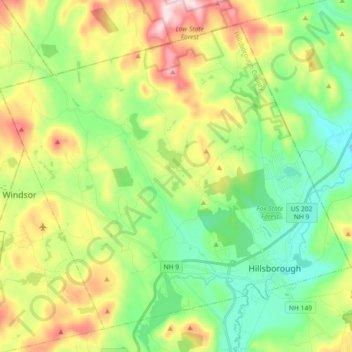
Name: Hillsborough topographic map, elevation, terrain.
Average elevation: 274 m
Minimum elevation: 118 m
Maximum elevation: 582 m
Other topographic maps
Click on a map to view its topography, its elevation and its terrain.
South Uncanoonuc Mountain
United States > New Hampshire > Hillsborough County > Goffstown
Average elevation: 243 m
Souhegan River
United States > New Hampshire > Hillsborough County > Milford > East Milford
Average elevation: 84 m
Piscataquog River
United States > New Hampshire > Hillsborough County > Manchester
Average elevation: 59 m
Souhegan River Watershed Dam Number 35
United States > New Hampshire > Hillsborough County > New Ipswich > Smithville
Average elevation: 349 m
West Peterborough
United States > New Hampshire > Hillsborough County > Peterborough
Average elevation: 299 m
Hillsboro Lower Village
United States > New Hampshire > Hillsborough County > Hillsborough
Average elevation: 242 m
Campbell Mountain
United States > New Hampshire > Hillsborough County > Hillsborough
Average elevation: 338 m
Massachusetts Drive Park
United States > New Hampshire > Hillsborough County > Nashua
Average elevation: 48 m
Souhegan River
United States > New Hampshire > Hillsborough County > Milford > East Milford
Average elevation: 84 m
North Brookline
United States > New Hampshire > Hillsborough County > Brookline > North Brookline
Average elevation: 124 m
Nakuru Lake
United States > New Hampshire > Hillsborough County > Hudson > Hudson Center
Average elevation: 80 m
North Village
United States > New Hampshire > Hillsborough County > Peterborough
Average elevation: 251 m
South Weare
United States > New Hampshire > Hillsborough County > Weare > South Weare
Average elevation: 210 m