
Chahar Burjak topographic map
Interactive map
Click on the map to display elevation.
About this map
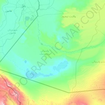
Name: Chahar Burjak topographic map, elevation, terrain.
Location: Chahar Burjak, Nimruz Province, Afghanistan (29.38959 60.87286 30.90364 63.15370)
Average elevation: 672 m
Minimum elevation: 452 m
Maximum elevation: 2,356 m
Other topographic maps
Click on a map to view its topography, its elevation and its terrain.
Kamal Khan Dam
Afghanistan > Nimruz Province > Chahar Burjak
Kamal Khan Dam, Chahar Burjak, Nimruz Province, Afghanistan
Average elevation: 517 m
Khash Rod
Khash Rod, Nimruz Province, Afghanistan
Average elevation: 693 m