
Vestre Aker topographic map
Interactive map
Click on the map to display elevation.
About this map
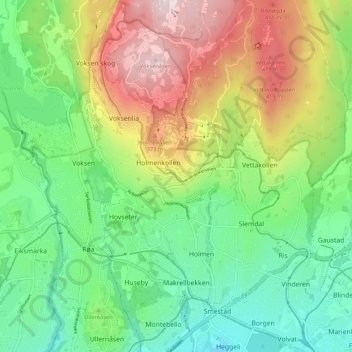
Name: Vestre Aker topographic map, elevation, terrain.
Location: Vestre Aker, Oslo, Norway (59.93147 10.61920 59.98510 10.71753)
Average elevation: 206 m
Minimum elevation: 23 m
Maximum elevation: 515 m
Other topographic maps
Click on a map to view its topography, its elevation and its terrain.