
Saint Elizabeth topographic map
Interactive map
Click on the map to display elevation.
About this map
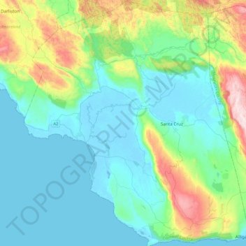
Name: Saint Elizabeth topographic map, elevation, terrain.
Location: Saint Elizabeth, Cornwall County, Jamaika (17.85443 -77.95212 18.25319 -77.56661)
Average elevation: 193 m
Minimum elevation: -6 m
Maximum elevation: 937 m
Other topographic maps
Click on a map to view its topography, its elevation and its terrain.