
Gear up for your next adventure:
As an Amazon Associate, this site earns from qualifying purchases at no extra cost to you.
Thank you for supporting this site ❤️
Make a donation
Make a donation
San Jerónimo topographic map
Click on the map to display elevation.
Gear up for your next adventure:
As an Amazon Associate, this site earns from qualifying purchases at no extra cost to you.
Gear up for your next adventure:
As an Amazon Associate, this site earns from qualifying purchases at no extra cost to you.
Thank you for supporting this site ❤️
Make a donation
Make a donation
About this map
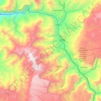
Name: San Jerónimo topographic map, elevation, terrain.
Location: San Jerónimo, Province of Luya, Amazonas, Peru (-6.10439 -78.17363 -5.90256 -77.93742)
Average elevation: 2,237 m
Minimum elevation: 837 m
Maximum elevation: 3,593 m
Gear up for your next adventure:
As an Amazon Associate, this site earns from qualifying purchases at no extra cost to you.
Thank you for supporting this site ❤️
Make a donation
Make a donation