
Tubas topographic map
Interactive map
Click on the map to display elevation.
Tubas
In the late 19th century during Ottoman rule in Palestine, groups of Arabs belonging to the Daraghmeh clan—mostly shepherds and farmers who lived in the Jordan Valley—migrated northward to the site because of its fertile ground, proximity to several springs, and its high elevation compared to the Jordan Valley and Wadi al-Far'a plain; Mount Gerizim was visible from the area. The Daraghmeh clan had lived in the Jordan Valley since the 15th century and in addition to Tubas, they founded or inhabited the nearby hamlets of Kardala, al-Farisiya, Khirbet al-Malih, Kishda, Yarza, and Ras al-Far'a. Soon after being established in Tubas, Arabs from Najd, Syria, Transjordan, Hebron and nearby Nablus came to settle in the area. During this period, Tubas became the site of clashes between the 'Abd al-Hadi and Tuqan clans of Nablus and suffered incursions by Bedouins from areas east of the city. The Jarrar clan did not inhabit, but administrated Tubas, as it was located within the nahiya ("subdistrict") of Mashariq al-Jarrar.
About this map
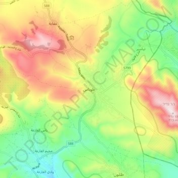
Name: Tubas topographic map, elevation, terrain.
Location: Tubas, Area A, Judea and Samaria, 1234, Palestinian Territory (32.28106 35.32891 32.36106 35.40891)
Average elevation: 377 m
Minimum elevation: 115 m
Maximum elevation: 711 m